


La Bassée 7.2 km

Blourouce
User
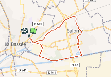

Length
7.2 km

Max alt
30 m

Uphill gradient
36 m
Km-Effort
7.7 km

Min alt
18 m

Downhill gradient
36 m
Boucle
Yes
Creation date :
2020-01-05 17:40:06.86
Updated on :
2020-01-05 18:04:50.518
--
Difficulty : Very easy

FREE GPS app for hiking
 SityTrail
IGN / Geographical institutes
SityTrail Plus
The world is yours!
About
Trail On foot of 7.2 km to be discovered at Hauts-de-France, Nord, La Bassée. This trail is proposed by Blourouce.
Positioning
Country:
France
Region :
Hauts-de-France
Department/Province :
Nord
Municipality :
La Bassée
Location:
Unknown
Start:(Dec)
Start:(UTM)
486706 ; 5598020 (31U) N.
Comments